Naruko Gorge, Autumn leaves like a picture on a folding screen

naruko gorge from ohfukasawa bridge (1) panoramic view
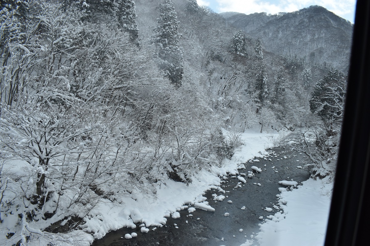
naruko gorge from train (1)

For backpackers coming from Sendai, I recommend getting off at the next station, Nakayama-daira Onsen, instead of Naruko Onsen Station (2.5 hours by JR from Sendai).  The reason for this is that you can briefly glimpse the core of Naruko Gorge that you are about to see between the tunnels passing through the gorge, and the walk from the station to Naruko Gorge is short (about 30 minutes) and there is a flat footpath.

naruko gorge from train (2)

However, as soon as you get off the train, you’ll see a quiet village that makes you wonder if you’ve made a mistake.  On the way to Naruko Gorge, you can see the steam rising from the hot spring village where the hot springs are gentle on the skin. You can stop by on your way home.

Naruko Gorge suddenly appears at the end of the pine forest. When viewed from the top of a steep cliff, it looks like a series of folding screens of autumn leaves.

naruko gorge upper (2) train

In the gorge at the bottom right, you can clearly see the railroad tracks that the train passed through earlier.  Many photographers are ready to take pictures of the train coming out of the tunnel exit on the cliff covered in autumn leaves.


Feeling depressed about the prospect of climbing back up, I descended from the steep cliff for 15 minutes and arrived at the deepest part of the gorge surrounded by cliffs covered in autumn leaves (Kaiko Bridge).

Returning to the top of the cliff, you can see the deep meandering of the Otani River, which created Naruko Gorge, from the midway point of Ohfukasawa Bridge, which is located directly above the Kaiko Bridge.

Beyond that bridge is the entrance to a quiet road that Edo period haiku poet Matsuo Basho wrote about in his travelogue on Oku no Hosomichi (about 45 minutes on the Ohfukasawa Promenade).    There is “Shitomae barrier for defense” nearby.


“Shitomae barrier for defense”

The literal translation of the Japanese word naruko into English is a crying child.   There is a theory that Naruko was named after the cry of a child that Minamoto no Yoshitsune’s wife gave birth to while he was on his way to Hiraizumi, and that the place was named “Shitomae barrier for defense”  because the child urinated there for the first time.

Basho is said to have been suspicious of this barrier official when he was leaving for Yamagata, and he also wrote a poem in which he woke up to a horse urinating on his bedside in the stable of a private house where he was staying in the constant rain.    However, it is said that this is just an exaggeration since they probably won’t be able to sleep in the stables.   When I read that haiku for the first time, I believed it with all my heart.

       “Plagued by fleas and lice,

                             I hear the horses urinating              

                                                                   Right by my pillow”


not just naruko cover photo
go bak to itinerary

Shirakaba Highland, a traditional Japanese resort

shirakaba highlands (2) center shirakaba lake

What conditions make it feel like a resort?     It is important not only to have a good view, but also to have a painterly color and a quiet atmosphere.


Perhaps it’s because the white birch (Shirakaba in Japanese) forest looks completely white and gives off a feeling that can’t exist in the ordinary world.    So why are pure white birch forest areas created?   This is because seeds in the soil stay dormant until the conditions are right, and when a forest fire or landslide leaves a ruin, they all switch to germinate all at once in order to suppress other plants and monopolize the area where they can grow as quickly as possible.   That’s why there’s a white forest all around, so it’s beautiful.    However, the lifespan of a tree is about 70 years, so the expression “beautiful and short-lived” can also be applied to these trees.

Lake Shirakaba View Point

Although it looks like a picturesque scene, Lake Shirakaba in the center of photos is actually an artificial lake.   There is a restaurant called Asahigaoka on this lakeside that serves very delicious soba noodles.    It’s more like a private house than a storefront.    You can also eat rainbow trout caught in Lake Shirakaba.    This is real, not artificial, indeed.

Detour (Goddess View Point on the way of Venus-Line)

Detour (Going down to Lake Tateshina on the way of Venus-Line)

shirakoma pond0 cover photo
go back to itinerary 

Moss Forest, a gathering place for people who love the world of Ghibli

shirakoma forest21
shirakoma forest3 moss

As soon as you step inside, you will be greeted by a ”moss forest” that covers everything from the ground to the roots of the primeval forest.    This scenery has been used in various TV commercials, so you may have seen it somewhere at least once.    It is said that 485 types of moss live there, so I went in with a magnifying glass, but I couldn’t really observe each one individually.

shirakoma forest6 huge rocks

Anyway, as I climbed up to the Takami-ishi Hut enjoying the scenery I had never seen before, I suddenly saw a mountain piled up with large rocks that looked like they had been piled up by giants.     If you drop something into a crevice between rocks, you will never be able to get it out, so be careful when climbing.    When you reach the top of the rocky mountain, you can see the round Shirakoma Pond floating just below, and beyond that you can see a vast panoramic view of the Saku and Karuizawa basins, and even Mt. Asama with its volcanic smoke behind them.


We crawled down the rocky mountain, passed the mirror-like shores of Shirakoma Pond, and returned to the parking lot through ”Mononoke Forest”, which is also reminiscent of the world of Ghibli.    It’s a different world for three hours above the clouds, but it’s a beauty that no amount of words can express.

The largest lake above the clouds, “Shirakoma Pond”

Detour (View Point)

Midway through the winding descent on the way back, at a point where my fellow passengers were beginning to feel uncomfortable, we came to the Hinata-Koba Observation Deck.     A resting place, not a detour.   You can see the Yatsugatake Mountains to the east, the Southern Alps and Kiso Mountains to the south, the Northern Alps to the west, and Mt. Tateshina at the northern tip of Yatsugatake.    I have never seen so many mountains in Japan in one direction.    The weather was so nice that day that I could see the summit of Mt. Yarigatake and was very impressed.


shirakoma pond0 cover photo
go back to itinerary

Ordinary tourists don’t go to Yokoya Ravine

yokoya ravine11 upper fall

Chino people cultivates the highlands at the foot of Yatsugatake mountains for farming, but the valleys are deep and it is difficult to get water on the highlands.    This Yokoya Ravine is one of those deep valleys.    On the other hands, during the season of autumn leaves, it is beautiful to look up from inside the valley, and from the high ground you can see the Central Alps beyond the carpet of autumn leaves.

yokoya ravine1 otome fall

From the Fairy Tale Road, take the side road to Yokoya Hotspring Hotel and first go down to Otome Falls.    However, this is an artificial waterfall.    They simply drop water by forming part of a waterway on a plateau where water is not available due to deep valleys.    I ended up taking many pictures thinking it was a completely natural waterfall.   Afterwards, we continued on the promenade for about an hour along the valley to the Ohtaki(King, directly translated) Falls, one of the highlights and the shape likes a crown, although we felt a bit uneasy along the way not meeting anybody.

Oshidori-Kakushi(Pair birds hidden, directly translated) Falls, another highlight located upstream, can be approached from the only opposite bank, so it is efficient to descend to Yokoya Ravine after seeing Mishakaike on Yumichi Street.    It is a dynamic waterfall with a large amount of water.

 You can also see this valley from the top of the hill, then return to the Fairy Tale Road and enter the side road that leads to the Yokoya Kannon view point deck.   After walking for about 30 minutes along a scenic promenade from the parking lot, you will arrive at the deck covered in autumn leaves.    From here you can see Ohtaki fall from above.    Furthermore, when I crossed the villa area on my way back to the Fairy Tale Road from Yumichi Street, I came across a family of deers many times.    We cannot tell you where it is, but if you see one, please pass by quietly so as not to startle it.

shirakoma pond0 cover photo
go back to itinerary 


Head to the nearby Uyuni Salt Lake without time and money

chichibugahama beach take5

Chichibugahama beach became quite famous on Instagram etc.     If you want to enjoy Uyuni Salt Lake, which reflects the whole sky like a mirror at your feet, only in pictures, check the time of low tide and sunset before heading there.

It looks majestic in the photo, but the shooting site is covered in mud, and everyone is looking into the viewfinder from a low posture.    Looking at Instagram, I still want to expect to see the magnificent scenery with the naked eye, but…..     There are three major disappointments in the world, but don’t let that happen here.     By the way, the three biggest disappointments experienced were “the Little Mermaid Statue”, which if you take a picture from the side rather than diagonally above, the factory area will be reflected in the background, “the Lorelei Rock”, which you won’t notice even if you were guided on a sightseeing boat, and “the Manneken Pis”, which is smaller than you thought.    But it’s not too bad.     It would be scary if Manneken Pis were huge. (A girl’s version of Manneken Pis was built nearby, but I don’t know what’s going on now.)

Kannonji

If I had a little more time, I would have liked to see the sand art of the Kan-ei Tsuho, a huge coin made in sand from the Edo period, from above.    Did you know that it was the title background of the TV historical drama program Zenigata Heiji.    However, it was close to sunset time, so I headed to the nearby Kamenoi Hotel in Kannonji.    Impressed by elaborate appetizers.

View of Mt.Kotohira in the morning from the opposite side of Konpira

konpira12 still steps
go back to itinerary


Overlooking the Seto Inland Sea from Mt. Shiude

hydrangea and islands3

There is a steep slope leading to the parking lot at the top of the mountain, so you should never walk from the coast.    However, just because you have arrived at the summit parking lot, you can’t feel relieved.   At the entrance of the slope leading to the observatory in the mountaintop parking lot, there are many canes like Konpira-san, which means that the steep slope continues from here furthermore.

When you reach the true summit, the view spreads out 360 degrees, but the sound of the waves does not reach you, it is quiet, and there is no sound, which is a strange feeling.    If you look closely, you can see Shikoku Niihama, Okayama Mt.Washuzan, and Seto Ohashi Bridge.   The highlight here is that you can see that the Seto Inland Sea is made up of regular repetitions of island-lined Seto and flat seas Nada without islands.

Panorama View (from west, north to east)

The Japanese archipelago has a complex topography due to the collision of multiple plates.    The Seto Inland Sea area was wrinkled diagonally by being pulled diagonally by the plate, and seawater inflowed here 10,000 years ago, and many islands formed at the tops of the wrinkles.

seto inland sea structure
Simulate by pulling cloth diagonally

Between the islands, the speed of the sea water at high tide and low tide makes it difficult for ships to navigate.    This is Seto.    Half a century ago, the song “Seto no Hanayome”(Bride from Seto) was popular in Japan, and it may have meant the rough seas of married life in the future .    Where there are no wrinkles, the sea is flat and calm.    This is Nada.    Between Kobe and Osaka, there is a long-established sake-producing area, which is famous as “Nada no Sake”(Sake of Nada).    You can see that Seto and Nada are clearly divided into east and west from Mt. Shiude.

Mt. Shiude seems to be very crowded during the cherry blossom season to enjoy the cherry blossoms and the beauty of the islands together. Reservations are required for those who drive to the parking lot at the top of the mountain, so be careful during this period.     If you are a good walker, how about climbing from the coast in this season?


konpira12 still steps
go back to itinerary

Climb the 785 stone steps and see Mt. Fuji from Konpira

konpira22 sanuki flat

Konpira-san has a strong character of the god of sea routes, but in the feudal era when people were prohibited from moving from distant regions, they were allowed to visit Konpira.   It is said that Konpira pilgrimage became very popular in the Edo period because no one could reach the main shrine unless they climbed 785 steps on their own, and because rumors were exaggerated after the people who visited the shrine returned home.

konpira10 a dog worships on behalf of its master

It is said that those who could not go by themselves wrapped money, goods, and addresses around their dogs, and entrusted those who went to the shrine to visit with their dogs.    If the entrusted person gave up on the way, it is said that he entrusted the dog to another person who was visiting.    This is a surprising system because it is close to the idea of ​​modern Internet protocols.

Before starting the climb, first fill yourself up with “Sanuki Udon”.    Shrines are often decorated with wooden sacred horses, but here there are two real horses that are not ornaments.    In addition, perhaps to pray for safe navigation, even a large screw is decorated.

konpira16 one step down

If you count the stone steps up to the main shrine, there are 786 steps. However, when the number is read in Japanese, it becomes “worry”(Na-Ya-Mu in Japanese), and it is bad luck even though you came to the shrine.   Therefore, inserting a stone stair that goes down one step to make a total of 785 steps is a very Japanese solution.    It’s a people who likes puns.    I don’t know where to go down one step when I’m dazed, but if I know in advance that I’m going to go down one step somewhere on the long stone steps, I feel nervous and have a little fun.

stone step upto tea house
Click above to refer to stone steps to Mt.Haguro Shrine

A similar story can be found at the 2446 stone steps on Mt. Haguro Shrine in Yamagata Prefecture.    Here, masons engraved something on the stone steps and mixed and matched stylishly designed stones to make you look forward to discovering them.    It makes me happy that Japanese people have had that kind of sense for a long time.

When you climb up to the main shrine, you will be so impressed by the view of the Sanuki Plain from there that you won’t even care about visiting the shrine (it’s a lie).    Beautiful cone-shaped small mountains are scattered in the flat plain, and this looks like small Mt.Fuji.    I believe that people who visited the shrine in the Edo period must have spread playful rumors that they could have seen “real” Mt.Fuji from Konpira.

konpira23 sanuki Fuji
konpira19 goal
konpira19 goal
konpira13 special presentation to the public of Jakuchu

The Shoin in the middle of the stone steps was the residence of Shinto priests.    This was where the high-ranking people visited, and in the room for visitors, you can always see the fusuma paintings of Maruyama Ohkyo and others.   The purpose of this travel is Jakuchu’s fusuma painting, which is extravagant because it is in the private room of the priest.    It is said that Jakuchu sent this to celebrate his inauguration as a Shinto priest, partly because the Shinto priest at the time had learned painting from Jakuchu.    How cool is that?    In addition to Jakuchu, there are wall paintings of countless butterflies by Gantai, and their detailed expressions make me stare at them.    I hope it will be published again someday.

https://www.nhk.or.jp/takamatsu/jakuchu/index.html

NHK Kagawa is filming the video, so you may be able to watch it on NHK’s favorite rebroadcast (archive).    There are many rebroadcast programs in recent years.    Even though I pay the same amount of NHK subscription fees, the number of broadcasting channels seems to be decreasing.

konpira21
go back to itinerary

That island occupied by rabbits

rabbit island0 welcome
rabbit island6 welcome

After landing that island you are immediately surrounded by huge number of rabbits.   There are lots of stories as to why rabbits were brought in Ohkuno island and bred.   Looking at the rabbits lying on their bellies and too relaxing even when people approach, it seems like a peaceful island.   However, ruins where the former army conducted poison gas experiments remain everywhere.  My delusion (story) is that after World War II, the GHQ (occupying American army) released the rabbits to confirm the safety of the poison gas removal process.

rabbit island11 too relaxed

Don’t forget to procure rabbit food before crossing the island.   Rabbits don’t care about people who don’t have food.

Rent a bicycle when you get to the island.   You can go around in about 30 minutes.   However, if you want to see the beauty of the many islands, you need to leave your bicycle and climb a little.

Detour

Did you know that Chukai, Takehara City has a headquarters and a factory that holds more than 50% of Japan’s jam market share?   It is  Aohata, which is the first company in the world to canned mandarin oranges grown in the Seto Inland Sea.    It is said that the president of Aohata, who watched a regatta race between the UK’s most famous universities, was impressed by the cheering of the blue flag.   English replacement of Aohata is a blue flag.      Visitable factories and photogenic shops are near Chukai JR station.

Jam factory
Jam factory


itsukushima shrine1
go back to itinerary

This one piece of picture!  Local train passing on the bridge

train passage on the bridge
tadami river bridge
tadami river bridge

There are various places to take a scenic view on the Tadami Line, but this is a must.
Tadami River First Bridge !


time schdule of train passage
time schdule of train passage on the bridge


Park your car at roadside rest area and walk 10min. to the viewpoint.  Many photographers are on standby.  Check time table of train passing on the bridge.

tou no hetsuri shrine
Go back to itinerary

Ouchijuku like a theme park welcomed by healthy old women good at business !

ouchijuku post town
ouchijuku roof material

Since the thatched roof is made from thin and manpower is required, dubbing work is done by all the villagers, which helps to form a community.

An ancient post town was on the highroad connecting Aizu and Nikko in Edo period.  Now it is left from main transportation route but the community keeps Ouchijuku remain as it is.  Thatched roof is not just beautiful, it is an important gimmick to maintain the community !

ouchijuku shop
oushijuku shop

At each thatched-roof house, a charming saleswoman sits at the edge of the porches and sells her own cooked food and crafts. Each item is hand-made, and the wallet’s string is loosened as the grandmother smiles.


Gallery (click photos)

tou no hetsuri shrine
Go back to itinerary